It is, therefore, about time I wrote something here about the experience!
This post looks at the NFM and SuDS projects we have been involved with in the Calder Valley to date. See post 1 for an overview of the group, how it has evolved and how we work with others.
Projects to date...
Hardcastle Crags 'Log Jams'
Slow The Flow: Calderdale (STF:C) have secured an Environment Agency (EA) grant to implement 'log jam' (lightly engineered, natural-looking) woody leaky dams at National Trust Hardcastle Crags. Building these will start soon, and STF:C are aware that our position as a voluntary group has enabled us to be more nimble in progressing the project than large organisations such as the EA and CC. This has been a good example of a synergistic relationship between the public and 3rd sector.River Surveys
STF:C have a team of volunteer surveyors who are working hard to survey all of the tributaries of the River Calder. The information they are collecting is helping us to better understand the catchment, and will be used in flood modelling to determine the most effective places for NFM interventions. I have been able to contribute GIS expertise in order to collate the river survey data into a Google Earth map, where the geo-located survey photos can be easily viewed to give an overview of the tributary network. Joining in with the survey work is also fun, and has proven popular with volunteers - fresh air, exercise, good company, and doing something useful to help manage flooding!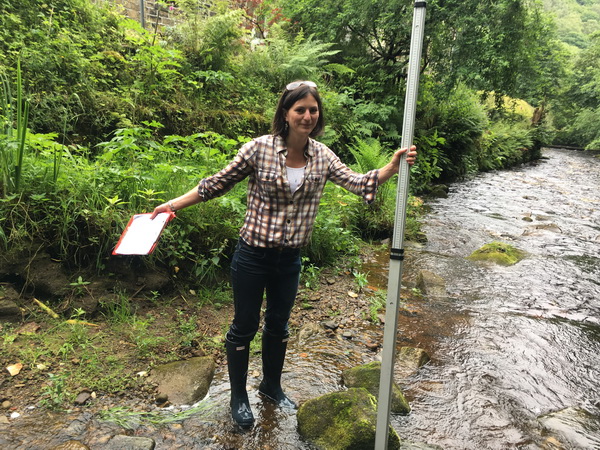
Image: Amanda out river surveying in Hebden Water (just after falling in - those are light blue jeans!)
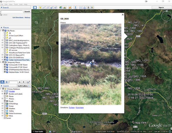
Image: The Google Earth map generated from the river survey photographs is a growing resource
Level Monitoring
STF:C also have a project in the pipeline to enable us to collect live river level data. This will inform the valley earlier about potential flood events, and help us to understand the impact that our interventions are having. Calderdale is currently classed as having a high density of EA river gauges. However, there are only a handful in the whole catchment, and only in the main river channels.STF:C want to provide dozens, perhaps hundreds, of gauges, created inexpensively using Raspberry Pi technology, to spread a net across the valley. This will enable us to give real-time information on the behaviour of the rivers, including the tributaries, and to scientifically understand their behaviour and the impact of our interventions. THe information can also be live-streamed to inform residents, who will gain greater peace of mind in times of heavy rain, and greater access to up-to-date information in times of flood, to supplement the EA's flood warning system, which is time-delayed. We also hope to involve school children, who will learn about the technology and the catchment, in order that they can care for it in their turn.
Urban Retrofit SuDS
Amongst all of the good work going on to implement rural NFM measures, 2B recognised that the greatest area of expertise we had to offer was in urban sustainable drainage. I am leading a project called 'You Can Slow The Flow', which aims to inform the public about how retrofit urban SuDS can contribute.The intention is that empowering the community will result in a reduction in combined sewer flooding, in particular - which is a problem in Calderdale, resulting in flood water becoming contaminated.
STF:C hope to make the concept of urban SuDS accessible to all, and encourage as many people as possible to join in. If every person in Calderdale (200,000 approx) stored an average of 0.1m³ (about a bathtub-full) of water in a flood event, we could store around 20,000m³ (about 5 m³ for every property that flooded on Boxing Day 2015).
The area has proven that community uptake of such schemes can have a powerful effect - Incredible Edible Todmorden works on a similar 'many hands' principle, has been phenomenally successful in changing Todmorden's fortunes, and is now being replicated all over the world.
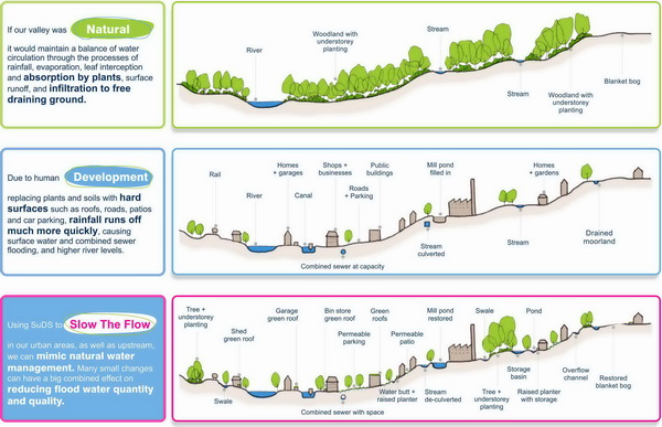
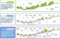
Image: Diagram from 'You Can Slow The Flow' project, explaining NFM principles
A suite of measures
All flood alleviation measures are needed in our valley, including rural NFM, urban SuDS, upland management, property-level resilience, and engineered walls.Individually, none of these measures can make a large enough difference to prevent flooding entirely and, perhaps, even together they still cannot. But they can prevent some smaller-scale floods, and, in larger flood events, can help reduce flood water depth and improve flood water quality. The cumulative effect of many smaller NFM and SuDS interventions, combined with other flood resilience measures, can make a big difference.
Proud to be involved
2B is delighted to be able to practice what we preach, and support Natural Flood Management in a meaningful 'bottom-up' way - as well, of course, as including SuDS in our schemes wherever appropriate.I am very proud to be a part of Slow The Flow: Calderdale, as both an affected resident and a Landscape Architect. I believe we can and will make a real difference to the severity of future flood events in Calderdale - but there is a lot still to do.
Find out more about how you can help, or follow STF:C on social media, at www.SlowTheFlow.net
By Amanda McDermott CMLI